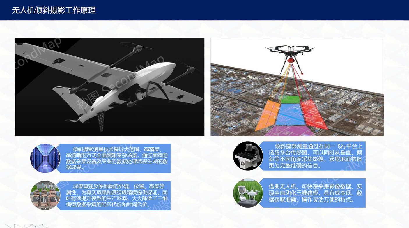
Constructing high-precision, multi-level 3D urban models, integrating multi-source data, building a digital twin city foundation, providing comprehensive 3D spatial information support for urban planning, construction, and management.
Multi-element Integrated Urban 3D Model
Urban 3D modeling is a multi-level, multi-element complex collection that comprehensively restores urban spatial information
Precise Digital Elevation Model (DEM) and Digital Surface Model (DSM), forming the 3D base of the city, accurately reflecting terrain undulations and surface morphology.
Core elements, from texture-free block models to detailed models with realistic materials, fully presenting urban architectural features.
Including road networks, bridges, tunnels, platforms and other transportation infrastructure, accurately reflecting traffic network layout and connectivity.
Pipelines, power grids, communication networks and other underground and aboveground infrastructure, building digital twins of urban lifeline systems.
Parks, green spaces, trees and other natural environment elements, restoring urban ecology and green landscape.
Urban furniture (street lights, benches), water bodies and key indoor spaces, perfecting urban detail representation.
Standardized process ensures model quality and efficiency, full-chain service from data collection to platform application
Comprehensive use of multiple advanced technical means to obtain comprehensive, accurate urban spatial data, providing high-quality data foundation for subsequent modeling.
Combining automation with manual refinement to construct high-precision urban 3D models, ensuring model quality and detail representation.
Professional optimization processing of models to improve loading and running efficiency while ensuring precision, meeting the needs of smooth large-scale scene display.
Importing processed models into professional platforms to achieve correlation analysis with multi-source data, leveraging the application value of digital city models.
Five-level precision system for building models, meeting the needs of different application scenarios
Block Model
Simple cubes, only representing the location, base and approximate height of buildings, used for macro planning and illustration.
Application Scenarios: Urban master planning, macro analysis
Standard Model
Basic appearance shape, roof structure, distinguishable main building components, with simple textures.
Application Scenarios: Regional planning, urban design
Detailed Model
With realistic textures and materials, clearly showing details such as windows, balconies and decorations.
Application Scenarios: Urban management, public services
Component-level Model
Including complete building components (such as beams, columns, doors, windows, etc.)
Application Scenarios: Facility management, maintenance and repair
Indoor-Outdoor Integrated
Including complete indoor detailed models, furniture and equipment, enabling seamless browsing from macro to micro.
Application Scenarios: Emergency command, immersive experience
Adopting industry-leading hardware and software tools to ensure model quality and project efficiency
Utilizing advanced oblique photography processing software to achieve rapid automated generation of urban models, significantly improving modeling efficiency and consistency.
Professional oblique photography modeling software, generating high-precision reality 3D models
Multi-source data processing platform, supporting rapid modeling from photos and point clouds
3D modeling software for surveying and mapping industry, automated feature extraction
UAV data processing software, generating DSM, DOM and 3D models
Professional 3D modeling software for detailed model production and editing, achieving high-precision, high-detail model representation.
Powerful 3D modeling software, widely used in architectural visualization
Open-source 3D creation suite, supporting modeling, animation and rendering
Professional 3D animation and modeling software, suitable for complex model production
Parametric modeling software, suitable for creating precise curves and surfaces
Realizing the integration of Building Information Modeling and Geographic Information System, constructing complete urban information models.
Professional BIM modeling software, creating building models with rich information
Professional GIS platform, realizing geospatial data management and analysis
Infrastructure engineering software, supporting full lifecycle information management
Urban modeling software, generating large-scale urban environments through rules
Used for final visualization presentation and interactive development, creating immersive urban experiences and professional application systems.
High-performance game engine, creating realistic real-time rendering scenes
Cross-platform game engine, suitable for developing interactive 3D applications
Open-source 3D earth platform, supporting large-scale geospatial data
Domestic GIS platform, supporting 2D and 3D integrated spatial information services
Whether you need to understand the details of 3D modeling technology or want to get a project quote, our professional team will provide you with one-on-one consultation services.
Room 1-1501, Jinhua Garden, No. 385 Jiaotong Avenue, Danyang Street, Xiaonan District, Xiaogan City, Hubei Province, China
(+86)13004585899
service@secondmap.cn
Scan with WeChat