Integrating multi-source data such as drone aerial photography, laser point clouds, and panoramic videos to build high-precision 3D models of factory space, providing millimeter-level precision spatial digital infrastructure for digital factory construction and empowering various digital information system applications
Digital Factory 3D General Layout and Spatial Information Platform
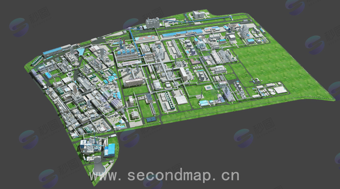
Integrating multi-source surveying and mapping technology with professional modeling processes to build high-precision, full-element, scalable 3D general layouts of digital factories, providing a solid spatial data foundation for enterprise digital transformation
Adopting professional surveying and mapping equipment and technical processes to achieve 1-3cm collection precision and L1-L5 level modeling precision, ensuring accurate mapping between digital models and physical factories to meet high-precision spatial analysis needs.
Covering full spatial modeling of factory outdoor space, indoor environment, and underground facilities, completely restoring factory buildings, equipment, pipelines, roads and other full-element information to build an all-round digital twin infrastructure.
Outputting common data formats such as FBX, BIM, GIS, compatible with mainstream engines like Cesium, UnrealEngine, Unity3D, can be seamlessly integrated into various digital information systems, supporting secondary development and function expansion.
Standardized technical processes and strict precision control systems ensure the quality and reliability of digital factory 3D general layouts
According to factory scope and precision requirements, develop detailed data collection and modeling plans, determine surveying and mapping scope, precision levels and delivery results
Combining drone aerial photography, laser point cloud scanning, panoramic shooting and other methods to comprehensively collect data on factory outdoor, indoor and underground spaces
Using professional software for data processing, modeling and optimization to build high-precision 3D models and restore various element details of the factory
Verifying model precision through professional testing methods and optimizing adjustments based on verification results to ensure meeting precision requirements
Output various common data formats, provide data integration support and technical documentation to ensure smooth application of customer systems
Highest precision level, suitable for scenes with extremely high precision requirements such as precision equipment areas and key production areas
High precision level, suitable for scenes with relatively high precision requirements such as production workshops and important facility areas
Standard precision level, suitable for scenes such as factory roads, outdoor venues, and auxiliary facilities
Diversified data result forms, widely applied in various digital information systems to empower enterprise digital transformation
Common 3D model formats such as FBX, OBJ, GLB, USDZ
Building information model formats such as Revit, IFC with attribute information
Geographic information data formats such as SHP, GeoJSON, MVT
Image data such as panoramic views, texture maps, orthophotos
Oblique photography services, 3D tile services, spatial query services
As the digital factory spatial infrastructure, integrating production, equipment, personnel and other information to achieve visual management and decision support of the factory
Combining 3D maps to achieve inspection path planning, security monitoring and abnormal event positioning, improving factory security management level
Realizing visual maintenance and management of equipment, pipelines and other facilities based on high-precision models to improve maintenance efficiency and accuracy
Providing accurate factory spatial information support to assist emergency event handling and command decision-making, improving emergency response efficiency
Carrying out planning design and plan simulation based on existing factory accurate models to optimize planning plans and reduce implementation risks
Using high-precision 3D environments to conduct employee training and simulation operations, improving training effectiveness and reducing training costs
Standardized service process to ensure efficient project implementation and high-quality delivery
Factory scope and precision requirement confirmation
Technical solution and implementation plan development
Multi-source data on-site collection operations
Data processing and 3D model construction
Precision testing and result acceptance
Data delivery and application training
Whether you need to understand the details of 3D modeling technology or want to get a project quote, our professional team will provide you with one-on-one consultation services.
Room 1-1501, Jinhua Garden, No. 385 Jiaotong Avenue, Danyang Street, Xiaonan District, Xiaogan City, Hubei Province, China
(+86)13004585899
service@secondmap.cn
Scan with WeChat